
Land Takings, 1803-1867
|
1782-1783: Treaties with the United Kingdom establish the U.S. as an independent country and establish the boundary of the United States as being bound on the north by Canada, on the south by Spanish Florida, on the west by the Mississippi River, and on the east by the Atlantic Ocean.
1803: The Louisiana Purchase extends the western boundary of the United States to the Rocky Mountains, occupying the drainage area of the Mississippi River, as estimated by the French explorer Robert La Salle. The Purchase doubles the territory of the United States.
1812-14: The U.S. declares war against Great Britain and attempts to take Canada. The Treaty of Ghent ends the conflict.
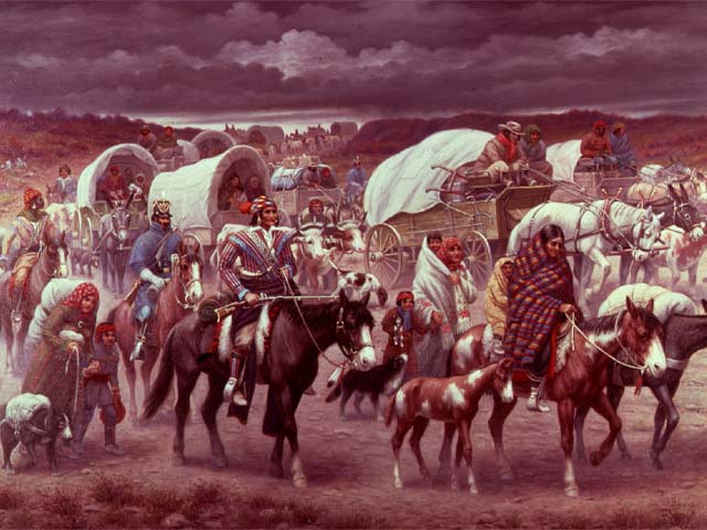 1814-1858:
Indian tribes are
removed from their lands in the original U.S., by treaty and by war, and
forced into lands in the Louisiana Purchase. Congress speeds up the process in
the Indian
Removal Act of 1830.
1814-1858:
Indian tribes are
removed from their lands in the original U.S., by treaty and by war, and
forced into lands in the Louisiana Purchase. Congress speeds up the process in
the Indian
Removal Act of 1830.
1818: A convention with the United Kingdom establishes the northern boundary of the Louisiana Purchase at 49°N.
1819: In the Adams-Onis Treaty Florida is purchased from Spain.
1820: Maine becomes a state, carved out of the state of Massachusetts. The northern boundary of Maine is disputed between the U.S. and Canada so the King of the Netherlands is brought in as an arbiter and he settles the dispute in 1829. However, Maine refuses the deal and since Congress requires the approval of a state legislature for boundary changes, the Senate cannot approve a treaty over the border. Ultimately, in 1842 a treaty establishes the Maine-Canada border of today although it provided Maine with less territory than the King's plan would have. The Missouri Compromise allows Maine to enter the union with a state constitution limiting slavery and Missouri to enter with a state constitution allowing slavery.
1845: The independent Republic of Texas (1836-1845), created by
American slave owners rebelling against Mexico, is
annexed to the
United States. The territory of Texas extends north to 42°N (into modern
Wyoming) due to a secret treaty between Mexico and Texas.
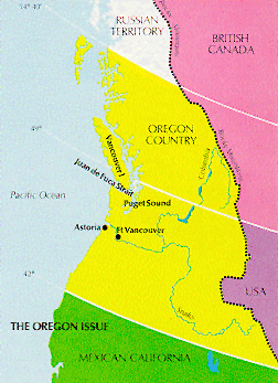
1846: Oregon Territory is ceded to the U.S. from Britain following an 1818 joint claim on the territory (James Polk runs for the presidency with an expansionist slogan: "Fifty-Four Forty or Fight!"). The Treaty of Oregon establishes the boundary at 49° North.
1848: The Treaty of Guadalupe Hidalgo following the Mexican War between the U.S. and Mexico results in the acquisition of Arizona, California, Nevada, New Mexico, western Texas, Utah, and western Colorado. The U.S. does pay some compensation to Mexico.
1853: With the Gadsden Purchase of 1853, the land acquisition that results in the area of the 48 contiguous states today is completed.
 1853:
1853:
1862-1863: When Virginia decides to secede from the Union at the start of the Civil War (1861-1865), the western counties of Virginia vote against the secession and decide to form their own state. West Virginia is established with help from Congress, who approve of the new state on December 31, 1862. West Virginia is admitted to the Union on June 19, 1863. West Virginia was originally going to be called Kanawha.
1867: Alaska is purchased from Russia for $7.2 million in gold. Some think the idea is ridiculous and the purchase becomes known as Seward's Folly, after Secretary of State William Henry Seward. The boundary between Russia and Canada was established by treaty in 1825.