From the Smithsonian: Native American History and Culture
(Source: Midwest Treaty Network: http://www.alphacdc.com/treaty/content.html)
ITD Summer Institute, 2006
American West Component
Presentations -- Additional resources
"Environmental History in the West"
American West Environmental History Bibliography from UC-Berkeley.
"Literature of the American West"
The Western Literature Association, A Literary History of the American West, 1987, complete book online.
Sources for Native American Literature
An American Nile, part two of the CADILLAC DESERT series, tells the story of how the Colorado became the most controlled, litigated, domesticated, regulated and over-allocated river in the history of the world. Rich with archival footage and interviews with the river's "shapers" and protectors, the broadcast chronicles how the Colorado became so dammed-up and diverted that by 1969 it no longer reached the sea except in the wettest of years.Despite the warnings to Congress in 1888 by explorer John Wesley Powell that the lack of water was a serious obstacle to unbridled settlement of the West, America was determined to settle the Colorado's starkly arid domain. In the height of the Great Depression, the heroic construction of Hoover Dam -- an engineering achievement compared to the Pyramids or the Sphinx -- made the Colorado into the greatest single source of electricity in the world, inspiration for dam builders the world over, and proof that the fatal dryness of the Great American desert could be conquered.
On the heels of the Hoover dam came a rush of hydroelectric dams, flood control dams, irrigation dams in California, Arizona, Montana, Washington, Oregon -- all engineering dryness and free-flowing rivers out of existence. Some 55 dams were built on the Columbia River and its tributaries alone -- including the colossal Grand Coulee; by 1956, 90 percent of its salmon were gone and nearly every stretch of the Columbia was a reservoir.
The same year, work began on the Glen Canyon Dam -- designed to generate both hydropower for Phoenix and revenue to pay for still more dams -- that would submerge 186 miles of canyonlands, destroying natural wonderland. Despite the last-minute efforts of the Sierra Club to stop the dam, the reservoir, named Lake Powell, was christened 100 years to the day that Powell had passed through Glen Canyon.
When the Bureau of Reclamation turned next to building two dams in the Grand Canyon, the Sierra Club engaged in a bitter battle -- and finally swayed public opinion -- to block them. But saving Marble Canyon did not stop the flood of people drawn to new homes and new jobs in Arizona, leading to President Lyndon Johnson's authorization of the Central Arizona Project, the most expensive waterworks in Bureau history. Today, with double-digit growth in Phoenix, there's just not enough water to meet insatiable demand. Whereas the Hopi have lived in the desert for a thousand years on tiny amounts of water, Americans built swimming pools and huge irrigation farms in the desert sun -- with water from the Colorado. No river has been asked to do so much -- for so many -- with so little.
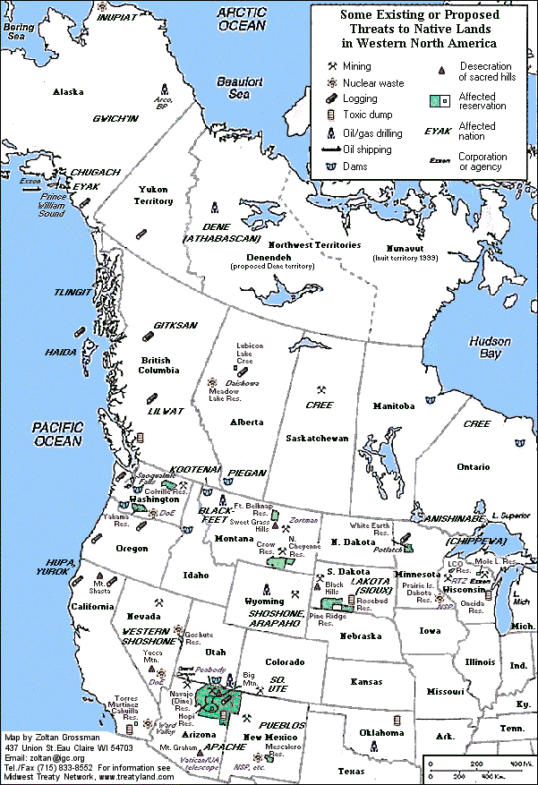
"Native American History and Culture"
From the Smithsonian: Native American History and Culture
(Source: Midwest Treaty Network: http://www.alphacdc.com/treaty/content.html)
"Issues in Native American Education"
From Northern Arizona University: a list of sources in American Indian Education
The B.I.A. Office of Indian Education Programs
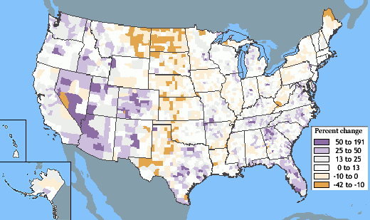
"The West: Everybody's Moving Here"
This map shows population growth between 1990 and 2000 for the country's 3,141 counties and equivalent areas. Some broad patterns are immediately evident. A band of counties that lost population—in some cases declining more than 10 percent—stretches across the Great Plains States from the Mexican border to the Canadian border. (Source: http://nationalatlas.gov/articles/people/a_popchange.html#four)
From the 2000 Census are a series of maps:
- Location Maps (1.3M) [PDF]
- Total Population (2.8M) [PDF]
- Diversity (1.4M) [PDF]
- White (3.1M) [PDF]
- Black or African American (3.4M) [PDF]
- American Indian and Alaska Native (3.5M) [PDF]
- Asian (3.7M) [PDF]
- Native Hawaiian and Other Pacific Islander (4.1M) [PDF]
- Two or More Races (1.2M) [PDF]
- Hispanic or Latino Origin (1.5M) [PDF]
- White, Not Hispanic or Latino Origin (3.2M) [PDF]
"The Immigrant Experience in the American West"
The Americanization movement of the 1910s and 1920s sought to train immigrants for citizenship and to help integrate an "unruly" West into the emerging national system. The movement's leaders were forced to reconcile the myth of rugged individualism with the demands of a planned society.
Hundreds of bureaucrats, educators, employers, and reformers participated in this movement by developing adult immigrant education programs—and how these attempts contributed more toward bureaucratizing the West than it did to turning immigrants into productive citizens.
Although racism and social control agendas permeated Americanization efforts in the West, Americanizers sustained their faith in education as a powerful force in transforming immigrants into productive citizens. Some westerners—especially in California—believed they faced a “racial frontier” unlike other parts of the country in light of the influx of Hispanics and Asians, so that westerners became major players in the crafting of not only American identity but also immigration policies.
The mystique of the white pioneer past still maintains a powerful hold on ideas of American identity, and we still deal with many of these issues through laws and propositions targeting immigrants and alien workers. --Frank Van Nuys, Americanizing the West, 2002.
An exhibit on Jewish People in the American West from the Autry Museum.
Black Immigration and the West
U.S. States in which no ethnic or racial group forms a majority.
"Supporting the New Students in the American West"
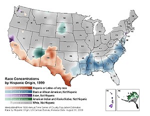
The increased gradation ranges represent the ethnic/race population as a percentage of the total population in that block group. For a group to be illustrated, the population of that group must be at least:
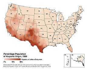
The increased gradation range represents 12.5% or more of Hispanic concentration as a percentage of the total population in that block group.
The increased gradation along the southwestern United States closely resembles the U.S.- Mexico borderline prior to the Treaty of Guadalupe Hidalgo, 1848. (Source: http://www.asu.edu/provost/swb/maps.html)
"Religion in the American West"
Internet Resources:
The Great Salt Lake occupies 2,500 square miles northwest of Salt Lake City, but it was once part of the much larger Lake Bonneville, which 18,000 years ago extended across 20,000 square miles including parts of Idaho and Nevada. The water level has declined rapidly on two occasions - once when the lake broke through the Sawtooth Mountains near Pocatello in Idaho and caused a devastating flood. The average depth of the lake now is only around 30 feet. The position of the previous two high water levels can be seen on the hills around the Great Salt Lake - ancient wave-cut terraces make clear dark lines across the rocks, about 550 and 900 feet above the present level.
The Lake: The lake is famous for its high salinity (which varies between 10 and 25%), second only to the Dead Sea of Israel, but the water tends to be rather smelly and there is not much of interest to see. However, a much more spectacular sight is provided by the great expanse of salt flats, remnants of the former Lake Bonneville, that extend south and west from the lake - this huge desert is almost completely white and level for over a hundred miles in some directions. It is said to be possible to see the curvature of the Earth at the horizon.
The Desert: A large proportion of the desert is used by the military; Hill Air Force Base to the north and the Wendover Gunnery Range to the south, and there have been many reports of the damage done to the land by the last 40 years of weapons testing. A large section is still accessible though - this is where I-80 crosses the desert. The interstate runs exactly east-west and is dead straight for almost 50 miles, between the Cedar Mountains to the east and Wendover on the Utah/Nevada border. The Great Salt Desert is well worth seeing - there is nothing else like it in America - although it is a long way from anything else scenically interesting.
I-80: In some places the salt is covered by a small depth of water; one good place to view the conditions is a rest area on I-80, 15 miles west of Wendover; it is quite an experience to walk a short distance into the salty wasteland. The ground is covered by very sharp salt crystals, so paddling is best not done barefoot. The opposite rest area for eastbound traffic is less good as there is a railway blocking the view.
Bonneville Flats: Nearby attractions include the Bonneville Flats, which has a race track and was the location for the land speed records set during the 50s, 60s and 70s. Recent deterioration in the quality of the salt surface has meant that such records are now attempted in the very remote Black Rock Desert of northwest Nevada which has flatter and more reliable ground. Wendover has casinos, so that the good people of Utah can experience the pleasures of gambling, and since the town is a little higher than the desert it is possible to see for many miles across the salt flats.(See: http://www.americansouthwest.net/utah/salt_lake_desert/index.html)
Also:
"Ogden's Historic 25th Street"