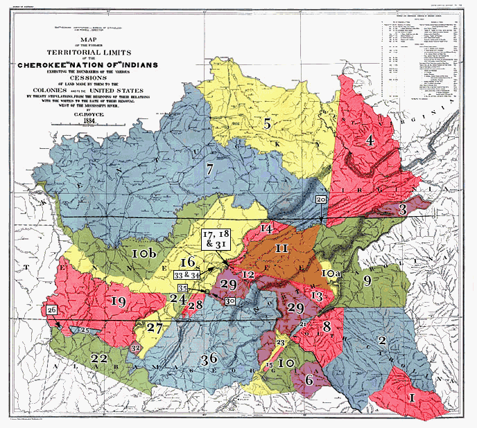
Cherokee Land Cessions
1884
|
![]()
No. |
Date and designation of Cherokee Treaties. |
Description of Cession |
Color. |
| 1. | Treaty of 1721 with South Carolina. | Tract in South Carolina between Santee, Saluda, and Edisto Rivers. | Red. |
| 2. | Treaty of Nov.24, 1755 with South Carolina. | Tract in South Carolina between Wateree and Savannah Rivers. | Blue. |
| 3. | Treaty of Oct. 14, 1768, with British Superintendent of Indian Affairs. | Tract in Southwestern Virginia. | Mauve. |
| 4. | Treaty of Oct. 14, 1770 at Lochabar, S.C. | Tract in Virginia, West Virginia, Northeastern Tennessee, and Eastern Kentucky, which is overlapped by No. 7. | Red. |
| 5. | Treaty of 1772 with Virginia.(1) | Tract in Virginia, West Virginia, and Eastern Kentucky. | Yellow. |
| 6. | Treaty of June 1, 1773 with British Superintendent of Indian Affairs. | Tract in Georgia, north of Broad River. | Mauve. |
| 7. | Treaty of March 17, 1775, with Richard Henderson, et al. | Tract in Kentucky, Virginia, and Tennessee (overlaps No. 4). | Blue. |
| 8. | Treaty of May 20, 1777, with South Carolina and Georgia. | Tract in Northwestern South Carolina. | Red. |
| 9. | Treaty of July 20, 1777, with Virginia and North Carolina. | Tract in Western North Carolina and Northeastern Tennessee. | Green. |
| 10. | Treaty of May 31, 1783, with Georgia. | Tract in Georgia, between Oconee and Tugaloo Rivers. | Green. |
No. |
Date and designation of Cherokee Treaties. |
Description of Cession |
Color. |
| 10a. | Treaty of nov.28, 1785, with the United States. | Tract in Western North Carolina. | Yellow. |
| 10b. | ...do... | Tract in Southern and Western Kentucky and Northern Tennessee. | Green. |
| 11. | Treaty of July 2, 1791, with United States. | Tract in Western North Carolina and Eastern Tennessee. | Brown. |
| 12. | Treaty of Oct. 2, 1798, with United States. | Tract in Tennessee, between Hawkin’s Line, Tennessee River, and Chilhowee Mountain. | Red. |
| 13. | ...do... | Tract in North Carolina, between Pickens and Meigs line. | Red. |
| 14. | ...do... | Tract in Tennessee, between Clinch River and Cumberland Mountain. | Red. |
| 15. | Treaty of Oct. 24, 1804, with United States. | Tract in Georgia, known as Wafford’s Settlement. | Red. |
| 16. | Treaty of Oct. 25, 1805, with United States. | Tract in Kentucky and Tennessee, west of Tennessee River and Cumberland Mountain. | Yellow. |
| 17. | Treaty of Oct, 27, 1805, with United States. | Tract in Tennessee of one section at Southwest Point. | Green. |
| 18. | ...do... | First island in Tennessee River above the mouth of the Clinch River. | Mauve. |
| 19. | Treaty of Jan. 7, 1806, with United States. | Tract in Tennessee and Alabama, between Tennessee and Duck Rivers. | Red. |
| 20. | ...do... | Long or Great Island in Holston River. | Red. |
| 21. | Treaty of Mar. 22, 1816, with United States. | Tract in Northwest corner of South Carolina. | Blue. |
| 22. | Treaty of Sept. 14, 1816, with United States. | Tract in Alabama and Mississippi. | Green. |
| 23. | Treaty of July 8, 1817, with United States. | Tract in Northeastern Georgia. | Yellow. |
| 24. | ...do... | Tract in Southern Tennessee. | Green. |
| 25. | ...do... | Tract in Northern Alabama, between Cypress and Elk River. | Blue. |
| 26. | ...do... | Tract in Northern Alabama, above the mouth of Spring Creek on Tennessee River. | Blue. |
| 27. | Treaty of Feb. 27, 1819, with United States. | Tract in Nothern Alabama and Southern Tennessee. | Yellow. |
| 28. | ...do... | Tract in Southern Tennessee, on Tennessee River. | Red. |
| 29. | ...do... | Tract in Tennessee, North Carolina, and Georgia. | Mauve. |
| 30. | ...do... | Jolly’s Island, in Tennessee River. | Red. |
| 31. | ...do... | Small tract in Tennessee, at and below the mouth of Clinch River. | Green. |
| 32. | ...do... | Tract of 12 miles square, on Tennessee River, in Alabama. | Mauve. |
| 33. | ...do... | Tract 1 mile square, in Tennessee, at foot of Cumberland Mountain. | Green. |
| 34. | ...do... | Tract of 1 mile square, at Cherokee Talootiske’s residence. | Green. |
| 35. | ...do... | Tract of 3 square miles, opposite mouth of Hiwassee River. | Green. |
| 36. | Treaty of Dec. 29, 1835, with United States. | Tract in Alabama, Georgia and Tennessee, being all the remaining lands east of the Mississippi River. | Blue. |