|
Resources:
Indian Affairs:
Laws and Treaties,ed. Kappler
Indian Claims
Commission Decisions
Access Genealogy posts legal
authority (laws) establishing
Indian Reservations
Utah American
Indian Digital Archives (U of U)
|

 Navajo
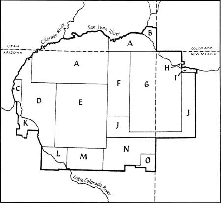
Navajo Reservation boundaries; adapted from Underhill
(1956).
Dates various parts of the reservation were added:
A-Ex. Ord. May
17, 1884
B-Ex. Ord. May 15, 1905
Act of Mar. 1, 1933
C-Act of May 23, 1930
D-Ex. Ord. Jan 8, 1900
E-Ex. Ord. Dec. 16, 1882
F-Ex. Ord. Oct. 28, 1878 |
G-Treaty of June
1, 1868
H-Ex. Ord. Dec 1, 1913
I-Ex. Ord. Apr. 24, 1886
J-Ex. Ord. Jan. 6, 1880
K-Ex. Ord. Jan. 19, 1918
Ex. Ord. May 23, 1930
and Act of June 14, 1934 |
L-Ex. Ord. Nov.
14, 1901
M-Act of June 14, 1934
N-Ex. Ord. Nov. 9, 1907
Ex. Ord. Jan. 28, 1908
O-Act of June 14, 1934 |
|
|
-
Treaty of 1868
- Conflict over the ranges in the Montezuma Canyon area continued
until it was divided in 1933. The Paiute Strip was officially added
to the Navajo Reservation.
- In 1991 a coalition of Navajos, Utes, mixed-blood Utes, and
other Indians orchestrated the passage of a landmark bill that gave
them increased representation in Utah politics. Legislation was
passed that established governance of the Utah Navajo Trust Fund.
Ute
 
- The
Mouache band lived on the eastern slopes of the
Rockies, from Denver, south to near Las Vegas, New
Mexico.
- The Capote
band inhabited the San Luis Valley in Colorado near
the headwaters of the Rio Grande and in New Mexico
especially around the region where the towns of
Chama and Tierra Amarilla are now located.
- The
Weeminuche occupied the valley of the San Juan River
and its northern tributaries in Colorado and
northwestern New Mexico.
- The
Tabeguache (also called Uncompahgre) lived in the
valleys of the Gunnison and Uncompahgre Rivers in
Colorado.
- The Grand
River Utes (also called Parianuche) lived along that
river in Colorado and Utah.
- The
Yamparicas (also called White River) band inhabited
the Yampa River Valley and adjacent land.
- The Uintah
Utes inhabited the Uintah Basin, including the Great
Salt Lake Basin.
Utah Ute (Uintah)
Colorado Ute (Uncompahgre, White River) -- now in Utah
Southern Ute
| 1880 |
Ute Agreement
signed. |
| 1894 |
Ute allotment
bill presented to Congress. |
| 1895 |
Ignacio led
most of the Weeminuche to the western part of
the Southern Ute Reservation in protest against
the government's policy of land allotment. |
| 1895 |
Utes agree to
the allotment bill. |
| 1896 |
New agency set
up at Navajo Springs to serve the Weeminuche who
did want to accept land in severalty |
| 1896 |
Allotments are
distributed to Southern Utes. |
| 1899 |
Southern Ute
Reservation opened to Anglo settlement. |
| 1937 |
Restoration Act
returns 222,016 acres to the Southern Utes. |
Southern Paiute

The Utah Paiutes and the federal government signed a treaty in 1865,
but it was not ratified by the Senate. The first reservation for the
Paiutes was established at Shivwits, near St. George, in 1891. Other
small reservations were established by executive order: Indian Peaks in
1915, Koosharem in 1928, and Kanosh in 1929. The Cedar City Paiutes were
treated as a scattered band and lived on land owned by the Mormon
Church.
In
the 1950's the Utah Paiutes' tribal status was terminated by Congress.
This caused many problems for the people for nearly 30 years. In the
1970s award money was given to the people to pay for land that was taken
many years before (27 cents per acre!) On 3 April 1980 President Carter
signed legislation that restored federal recognition for the Paiute.
Shoshoni
Eastern - Wind River
In 1868, Washakie and a council of
tribal elders signed a treaty formally establishing the Wind River
Reservation in Wyoming.
Northern - The four remaining
groups of Shoshoni are usually listed under the general name of the
"Northern Shoshoni."
- One of these groups, the Fort Hall Shoshoni of
about 1,000 people, lived together with a band of about 800 Northern
Paiute known in
history as the Bannock at the confluence of the Portneuf and Snake
rivers.
- A second division, the Lemhi, numbering some 1,800 people,
ranged from the Beaverhead country in southwestern Montana westward to
the Salmon River area, which was their main homeland.
- In western Idaho,
along the Boise and Bruneau rivers, a third section of about 600
Shoshoni followed a life centered around salmon as their basic food.
- The fourth and final division of 1,500 people, the Northwestern
Shoshoni, resided in the valleys of northern Utah--especially Weber
Valley and Cache Valley--and along the eastern and northern shores of
Great Salt Lake.
Western -- occupied what is today
northern and western Nevada. There were as many as eleven major bands
distributed from the present Utah-Nevada border to Winnemucca on the
west. Their descendants today live on the Duck Valley Reservation or
scattered around the towns of northern Nevada from Wells to Winnemucca.
The Duck Valley Indian
Reservation is situated on the
Nevada/Idaho border. Established
by Executive order on April 16,
1877, the site for this
reservation was selected by
Captain Sam, a Shoshone leader
who felt that the plentiful wild
game, fishes, wild
berries, abundant water and the
fertile valley soil held a
promising future for our
people. In 1886 and again in
1910 additional land was
annexed.
Goshute
Federal authorities established a
government farm at Deep Creek for the Goshutes in 1859, but the project
was abandoned by the next year. Attacks on the Pony Express and Overland
Stage, which ran through traditional Goshute territory, resulted in an
1863 treaty between the Goshutes and the federal government to allow
peaceful travel through Goshute country. The Goshute did not cede any of
their territory in the treaty, but federal officials were intent on
removing the Indians. Between 1864 and 1912 they undertook efforts to
remove the Goshutes to the Uintah Basin, Idaho, Nevada, and Oklahoma,
but when these attempts failed, the Goshutes received reservation land
in their native Utah. The Skull Valley Reservation was created in 1912,
and the Deep Creek Reservation was formed in 1914.
Comanche

On March 29, 1858,
officials recommended the abandonment of the
Comanche reservation (as well as the Brazos
reservation) and removal of the Indians to
Indian Territory. Orders for their complete
removal were issued on June 11, 1859. The two
groups were consolidated at the Red River, and
on September 1 Neighbors delivered them to
agency officials in Indian Territory.
Apache

-
White
Mountain Apache (comprising the
Arivaipa, Tsiltaden or Chilion,
Chiricahua, Coyoteros, Mimbrenos,
Mogollones, finals, '"San Carlos,"
and Tontos), under Ft Apache agency
-
Apache
consisting of the same divisions as
above, under San Carlos agency
-
Apache
at Angora, Ariz.
-
Jicarillas in New Mexico
-
Mescaleros in New Mexico
-
Chiricahua at Ft Sill, Okla.
Nez Perce
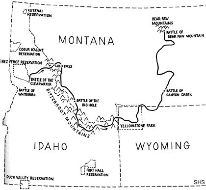
Coeur
d'Alene Reservation: Coeur d'Oreille (Skitswish),
Kutenai, Pend d'Oreille, and Spokan Indians
Executive orders, June 14, 1867, and Nov. 8,
1873; agreements made Mar. 26, 1887, and
Sept. 9, 1889, and confirmed in Indian
appropriation act approved Mar. 3, 1891;
agreement of Feb. 7, 1894, ratified by act
of Aug. 15, 1894
Pueblo

Pueblo lands
were confirmed by United States patents in
1864, under old Spanish grants; acts of
Congress approved Dec. 22, 1858 and June 21,
1860.
- Acoma
-
Three
reservations
make up Acoma
Pueblo: Sky City
(Old Acoma), Acomita,
and McCartys. The
Acoma Pueblo tribe
is a federally
recognized tribal
entity].
The historical land
of Acoma Pueblo
totaled roughly 5
million acres; now
only 10% of this
land is in the hands
of the community.
he Acoma have
continuously
occupied the area
for over 800 years,
making it the oldest
continuously
inhabited
communities in the
United States.
- Cochiti
- Hopi
- Isleta
- Jemez
- Laguna
- San
Ildefonso
- San
Felipe
- San
Juan
- Sandia
- Santa
Ana
- Santo
Domingo
- Taos
- Zia
- Zuñi
|


