Post-Civil War Surveys of the West
Chronology
- 1860 California Survey under Josiah Dwight Whitney. Team included Clarence King who climbed the mountains and wrote in 1872 Mountaineering in the Sierra Nevada.
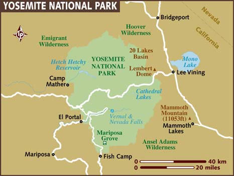
By1870 Whitney and his men complete their survey of all the known mineral deposits in California. Published Geography of California. During the course of his work, Whitney uses influence in D.C. to persuade President Lincoln to grant Yosemite Valley to California for a public park (1864). John Muir helped spark the creation of Yosemite National Park in 1890.
- On March 2, 1867, Congress for the first time authorized western explorations in which geology would be the principal objective: a study of the geology and natural resources along the fortieth parallel route of the transcontinental railroad, under the Corps of Engineers, and a geological survey of the natural resources of the new State of Nebraska, under the direction of the General Land Office.
Clarence King and a team were out every year from 1867 to 1872 mapping the 40th parallel, studying the geology, looking for gold deposits, collecting plants and animals. King served as the first director of the U.S. Geological Survey when it was organized in 1879.
- The second new exploration in 1869 was led by Lieutenant George
Wheeler, Engineer Officer on the staff of the Commanding General of
the Army's Department of California (which covered California,
Nevada, and Arizona). By 1869, exploration of the Colorado
River and location of north-south routes across the Great Basin had
become the most important projects of the Division of the Pacific,
but when the Army learned of Powell's planned expedition,
exploration of the Colorado was postponed.
In early June 1869, Lieutenant Wheeler received orders to organize and equip a party to make a thorough and careful reconnaissance of the country south and east of White Pine, Nevada, as far as the head of navigation on the Colorado, to obtain data for a military map and to survey the possibility of a wagon road and select sites for military posts.
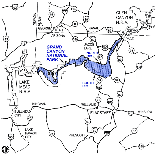
In 1871, the Engineers sent Lt. Wheeler to explore and map the area south of the Central Pacific Railroad in eastern Nevada and Arizona. On his return from the expedition, Wheeler proposed a plan for mapping the United States west of the 100th meridian on a scale of 8 miles to the inch. Congress authorized the program on June 10, 1872, the day on which funds were appropriated for completion of the Powell survey. By 1879 when his survey was terminated, Wheeler had mapped almost one-third of the country west of the 100th meridian. Photographer Timothy O'Sullivan was on the 1871 Grand Canyon Expedition. Wheeler was the last of the army explorers in the West. His survey gave way to the civilian-controlled U.S. Geological Survey in 1879.
- In May 1869 John Wesley Powell and 9 volunteers set off to explore
the Colorado River of the West.
In 1871 Powell makes the trip again, mapping and surveying the route carefully and giving a name to the whole canyon country -- the Colorado Plateau. Powell's team becomes the "United States geological and Geographical Survey of the Rocky Mountains" operating first under the Smithsonian Institution and then under the department of the Interior. (photographers Beaman and his replacement Hillers accompanied the team.
Although first afforded Federal protection in 1893 as a Forest Reserve and later as a National Monument, Grand Canyon did not achieve National Park status until 1919, three years after the creation of the National Park Service.
In 1878 Powell published A Report Upon the Lands of the Arid Regions of the United States. Powell served as second director of the US Geological Survey (1881–1894)
-
Ferdinand V. Hayden so pleased Congress with his State survey of Nebraska that in 1869 he was made head of the "United States Geological and Geographical Survey of the Territories."
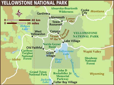
In 1871 Hayden led an expedition into Yellowstone. Photographer William H. Jackson and painter Thomas Moran accompanied the group. Hayden promoted the Yellowstone Park bill which passed in 1872.
Inevitably, conflicts developed between the Hayden survey, mapping the Territories of the United States, and the Wheeler survey, mapping the areas west of the 100th meridian. In 1874, Congress was provoked to a thorough discussion of civilian versus military control of mapping. In the testimony heard by the Congressional committee, much of it on the purposes and efficiency of the mapping, Powell credited King's Fortieth Parallel survey with the most advanced techniques, which Hayden and he had later adopted. In the end Congress concluded that each survey had been doing excellent work for the benefit of the people and that there was sufficient work for both the Interior Department and the War Department.
- In 1878, deterioration of the economy led to another consideration of the problem of mapping the West. The King survey had by this time completed its reports, but the Hayden, Powell, and Wheeler surveys were still in the field. This time Congress turned to the National Academy of Sciences and asked it to recommend a plan for surveying and mapping the Territories of the United States that would secure the best possible results at the least possible cost. A committee of seven members appointed by the Academy recommended that an independent organization, to be called the U.S. Geological Survey, be established in the Interior Department to study the geological structure and economic resources of the public domain. In establishing the organization, Congress also also provided that the Hayden, Powell, and Wheeler surveys be discontinued as of June 30, 1879.
(Sources: Exploring the American West, 1803-1879 (National Park Service, 1982) and http://pubs.usgs.gov/circ/c1050/surveys.htm)