Clarence King was one of a new breed-civilian scientists who rapidly replaced the Army in the work of surveying the West. King organized the Geological and Geographical Survey of the Fortieth Parallel under the sponsorship of the Army. His survey report included practical information of great use to the mining industry. King's quest for good science led to reports that were the first thoroughly professional studies of the Western environment.
Four Great Surveys of the West
Description of the surveys from USGS
A Clarence King Gallery from the USGS
Beyond Lewis & Clark (online exhibit from the Kansas Historical Society)
William Henry Jackson photo collection at BYU
Wheeler Survey photos from the USGS
The O'Sullivan photo archives are at Eastman House
E.O. Beaman photos (with Powell expedition) at USGS
Jack Hiller photos (with Powell expeditions)
With the conclusion of the Civil War, the Federal government made investigating, mapping and understanding the Western territories an integral part of its domestic policy. Washington wanted to know whether the land could be farmed, what its natural resources were, and how easily it could be settled. It was with this in mind that, from 1867 to 1879, legislators on Capitol Hill sponsored what came to be known as the four "Great Surveys." Each of these were grand undertakings both in terms of the amount of territory they examined and in the wealth of information contributed to the knowledge of the American West.The four surveys individually made enormous contributions to the existing knowledge of the West. The beautiful maps, for example, so painstakingly compiled were accurate enough at the time to be helpful for railroad builders and farmers. However, the U.S. Geological Survey eclipsed them, and much of what they had achieved was quickly forgotten. But even though the Hayden, Powell, King, and Wheeler expeditions were superseded by Powell's new agency, these four pioneers did achieve what they had set out to: They had explored the West and discovered what lay out there.
The survey of the 40th parallel led by Clarence King (1867–78)

the 100th-meridian survey led by George Wheeler (1872–79)

The geographical surveys west of the 100th meridian of the United States operated under a general plan issued by the Chief of Engineers of the U.S. Army Corps of Engineers and were under the supervision of First Lieutenant (later Captain) George M. Wheeler. The first expedition took place in 1869; the last in 1879.
The geologic survey of Nebraska and Wyoming led by Ferdinand Hayden (1867–78)
The Hayden Geological Survey of 1871 explored the region of northwestern Wyoming that later became Yellowstone National Park in 1872. It was led by geologist Ferdinand Vandeveer Hayden. The 1871 survey was not Hayden's first, but it was the first federally funded, geological survey to explore and further document features in the region soon to become Yellowstone National Park
, all rights reserved.")
|
Members of the 1871 Hayden Expedition. |
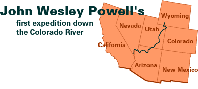
Geographical and Geological Survey of the Rocky Mountain Region, led by John Wesley Powell (1869 - 1879)